28/03/2011

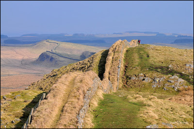
Setting sun over Hadrian's Wall

The clocks have changed giving us more evening time so I, like quite a few other people, took advantage of a nice night to head out for a walk on the Hadrian's Wall Path at Cawfields.

The light on the quarry face was lovely but a breeze was rippling the water spoiling the reflection, so I headed uphill following the HWP past the milecastle and onto Cawfield Crags.

Birds were singing and mists were rising, I was hopeful of a nice sunset, until I noticed the bank of cloud along the horizon.

Ever optomistic I thought the sun would go behid the cloud and send some ruby coloured rays the light the darkening sky.

It didn't but, maybe next time.


Setting sun over Hadrian's Wall on Cawfield Crags


Mists rising over the Roman Fort of Aesica next to Great Chesters Farm, Mucklebank Crags are on the horizon and the two trees on the skyline to the left as you look at the picture mark King Arthur's Well.

I've changed the layout of the Blog page so you can view the larger size images without having to click on them.
As always the photographs used on this blog are copyright of Joan Thirlaway and can't be used without written permission.

27/03/2011

Walltown Quarry Lake

I'd seen the Little Grebe when I was out taking the misty photographs at Walltown Quarry, so back I went with my big lens, welly boots and a stool (might as well be comfortable).
When I tried yesterday the birds seemed nervous and kept well away from me, across the far side of the lake, so today I took a camo poncho to drape over the tripod legs and what a difference it made.
This tiny bird took very little notice of me, looking my way when it heard the shutter fire but not nearly as nervous as it had been yesterday.
Guess I shall have to make some camo leg warmers for my tripod!
Saw two pairs of Oystercatchers piping and dancing for the territory, fascinating displays, the Little Grebe didn't like the noise and hid away in the reeds until it was over.
So we have the Little Grebe or Dabchick as it's known and those are the pictures I'm sharing with you today.

Little Grebe (Tachybaptus ruficollis)


I think the Dabchick was watching movement under the water, it did this and then flattened it's plumage to dive.


Typical Grebe head


A Caddis Fly for lunch, it caught a variety if insects and dashed them about (at great speed in the water making photo's difficult) certainly no shortage of things to eat.

As always click on the photograph if you'd like to see a larger size.
All photographs used on the Blog are copyright of Joan Thirlaway and cannot be used without written permission

26/03/2011

Hadrian's Wall at Walltown

Full of cold today so it'll be short, and hopefully sweet.
Fog at sunrise so I know there wasn't much point in making the trek to catch the sun coming up.
Checked the NNPA webcams and as soon as I could see a bit of blue I headed out to Walltown.
Fog and mist never quite performs to order and the scene had changed completely when I arrived, the lake was a swirling mass with the island in the middle making a ghostly impression, ducks bobbed asleep in the foreground.

I did notice a Dabchick diving on the lake, it's on my list to photograph so I was pleased to see it back at Walltown.
I headed for higher ground, hoping to get above the mists and find some sunshine to brighten the scene.
There are lots of mature trees on the slopes of Walltown Crags and they were stunning with swirls of mist and rays of light breaking through.
Over on the Pennines a lone pylon breached the fog .


Mists came and went, so just as I thought I'd got enough photographs I turned around to take some more, and I share a selection of those with you now.


The view across the plain over Longbyre from Hadrian's Wall at Walltown


Swirling mists on Walltown Crags

Mist is clearing in the valley below


William's lambs on Walltown Crags


Mucklebank Crags appear through the mist


More of Hadrian's Wall becomes visible as the sun burns off the mist


The Hawthorn tree with a view of Walltown Quarry. The island in the middle of the lake was barely visible in the first picture on today's blog


 Mallard sleeping in the sun but keeping an eye on me, just in case.

If you click on the pictures you can see a larger version, all pictures on the Blog are copyright of Joan Thirlaway and can't be used without written permission.

24/03/2011

Oystercatchers

You know that saying 'if at first you don't succeed'?
I try, goodness only knows I try, so it was back to Mawbury in search of Oystercatchers.
High tide was projected at 2pm and the early morning fog was clearing beautifully as I drove from Gilsland.
It was 12.15 when I arrived at Mawbury garden centre with a beautiful blue sky and just wisps of fog, rapidly clearing - or so I thought.
Decided to stop for coffee and scone as I had plenty of time (both excellent by the way) and when I came out it was like pea soup.
Thinking it would go as quickly as it came, I optomistically set off for the beach carrying my biggest lens and heavy tripod.
And wouldn't you just know it, there were hundreds of Oystercatchers but the fog just kept on rolling in with the high tide.
I got some pictures and I will admit as I stood there thinking I m,ust be mad, droplets of water running off my hair and specs misting up, when just a mile inland it was a beautiful sunny day.
No amount of pleading, cajouling and threatening the weather gods changed things, so I just carried on snapping.
It'll be a while before the high tides are at useful times of the day, but I will try again.

One man and his dog (Trev and Chloe) on foggy Mawbury beach

The flock of Oystercatchers, there were masses of them and a big flock of Curlew hidden in the mist behind them that I didn't even see until I enlarged the photographs on my computer screen

My favourite shot of the day, because of the fog the camera was having trouble focusing,
 fortunately it managed for this shot. (click on the picture to see a larger version)

It's a great coast for birds and well worth the hours drive from Gilsland, however the tide goes out a mile I've been told so it's best to check the tide tables and go when there's a high tide.
There are various parking spots along the roadside dunes and toilets at the garden centre, or in Silloth.

22/03/2011

Bellingham

A free day with promising weather had us thinking of a trip out.
It's ages since we've been to Bellingham, a Northumbrian Market Town just 30 minutes drive from Gilsland.
I wanted to visit the waterfall at Hareshaw Linn , it's in the ownership of Northumberland National Parks and has a well maintained pathway along the river edge.
This is known as the 'Waterfalls Walk' and there are several along the 1.5 mile walk, only two are accessible for photographs though.

The first waterfall by the picnic area

While the footpaths and bridges along the route are excellent, the views along the river are blocked by twiggy, scrubby branches.
 Lots of fallen trees across the river and while it's a natural environment and good for wildlife it does spoil the viewpoints as you can see in the following picture.


The scrappy saplings obliterate the view through to one of the waterfalls.

At the very end of the walk is Hareshaw Linn and you can get clear views of this waterfall and if you are agile from several different points.
It's an impressive fall and, in my opinion, well worth the walk along the track.

 Hareshaw Linn Waterfall, you know when you've reached it as the path ends here.

Detail in the waterfall

There's a car park near the start of the walk and it's less than 5 minutes walk into the town where there are plently of places where you can get a coffee or something to eat.
The Bellingham Heritage Centre is a museum of Northumbrian farming history and while I haven't visited I've heard it's very good.
It's only 17 miles to Kielder from Bellingham so maybe you could make a full day out combining the two destinations.

If you click on the photographs you will be able to see a larger version.

21/03/2011

More Wildfowl

Been to a Parish Council  meeting tonight (I sit at the back and heckle) it went on longer than normal so I'm just posting pictures with a title.
Taken on a nice day at Caerlaverock, I'd hoped to get the shot of Barnacle Geese that I have in mind but they stayed well away from the camera.

Male Shoveler

Dunnock signing it heart out to claim a territory


Whooper Swans, some of these will be last years cygnets all their fluffy grey feathers have gone.


Whooper Swan landing


Whooper Swans heading towards the light. In a large version of this you can see a trail of water drops behind the swans.

20/03/2011

The River Nith at Dumfries

A nice bright day when I headed out to Dumfries.
The River Nith runs through the town and there are pretty walks along the river bank.
I'd gone hoping to see the Mergansers and if I was lucky the Otters.
There's normally ample free parking alongside the river, you need one of those discs that you alter to say when you arrive and you're allowed to stay for three hours.
On this particular day the 'amusements' were in town, taking up the parking area by the weir.
The river was running high, so no gravel banks or much else to see, not good conditions for seeing otters as there were no river edges.
The 2 Mute Swans came to see if I had any food but quickly lost interest in me when I didn't feed them.
The views are lovely but I was after Mergansers so I headed north along the footpath.
I was on the point of giving up when I spotted a lone female under one of the footbridges.
Then a male came into sight. I took a few photo's then it was off surging up the river at some speed before diving.
If it was fast on top of the water it was super fast under it and I was trying to hurry, with my heavy  tripod et al, to be ahead of it when it surfaced.
Thankfully no one was around to see me lumbering along, the Merganser took notice but in a bemused sort of way, eventually the bird flew off, no way I was going to catch up.
I got a good number of shots and wandered back to the care hoping just some of them would be sharp and the right exposure.
One of these days I'll actually look round Dumfries.


Please click on the photograph if you'd like to enlarge it.
all photographs used on the blog are copyright of Joan Thirlaway and cannot be used without written permission.

16/03/2011

Hadrian's Wall: Housesteads Crag

Like most places we had fog today, I sat out in the garden taking bird photographs and considering the conditions got some nice photo's but nothing you haven't seen many times before so I was back in my files for something of Hadrian's Wall.

Housesteads Crag doesn't seem to be mentioned much but it's a pretty impressive crag and from the walk through the woods ( the only part of Hadrian's Wall you're allowed to walk on ) you get a view of the loops and undulations of the path Hadrian's Wall took.
I had to wait ages for a person to come along and give the view a sense of scale.


Hadrian's Wall with Cuddys Crag and Hotbank Crag, the walkers are just cresting Cuddys Crag

Cuddys Crag is one of the favourite viewpoints on Hadrian's Wall, looking east over Housesteads Crag and onwards to Sewingshields Crag.
Soon the sun will be rising behind the trees on Housesteads Crag and my early morning outings will begin.

Housesteads Crag from Cuddys Crag

The stones of Hadrian's Wall are covered in lichens and mosses, some of them I'm sure are unusual. I did buy a book to see if I could identify some of them but many are very similar and can only be told apart with a strong magnifying glass. I'm sure most  people walking the Hadrian's Wall Path don't give these plants a second glance, in fact many don't give the scenery a second glance either in their rush to finish the walk.

Lichens on the stones of Hadrian's Wall

I'm lucky enough to have the time to stand and stare, enjoying all that nature has to offer (well all but the fog and rain that is )

Click on the photographs if you'd like to see tham in more detail.

all photographs used on this Blog are copyright of Joan Thirlaway and cannot be used without written permission.

15/03/2011

Hadrian's Wall: Willowford Bridge

There's a circular walk I do from my home in Gilsland up to Birdoswald Roman Fort and back.
Following the Hadrian's Wall Path from Gilsland as it heads downhill at Willowford you can see the abutments of the Roman Bridge.

Hadrian's Wall at Willowford, the wall ends at the bridge abutments but, unlike the new bridge to the left in this picture, the Roman bridge headed straight up the cliff in front of you, an amazing feat of engineering.


The line of the River Irthing has changed since Roman times, leaving the remains several metres from the river, there are interperative boards that show you how the bridge would have looked then.

The River Irthing by Willowford Bridge, great place for a picnic, and for a fossil hunt.

Once you pass this point going west you head uphill, in spring the edges of the track are lined with wild primrose.
It's a fair pull uphill and the track had quite large loose stones so you must take care.


The view east from Birdoswald towards Walltown Crags

This is almost the view you get straight out of the car park so it's a good place for anyone who can't walk far. During the season you can also visit Birdoswald Fort.


The view over the valley from the road, I am trying to show just how much difference in level there is between the two ends of the Roman Bridge, it must have been such an impressive sight joining the two parts of the bits of Hadrian's Wall that are left, from the Irthing Valley to the plateau above.

14/03/2011

Grune Point on the Solway

I had a trip across to the English part of the Solway Coast yesterday.
It's an hours drive from Gilsland and has Roman remains, as it's a little known fact that Hadrian's Wall followed the coast down to Maryport
On this occasion I wasn't looking at Roman remains but at birds.
The whole of the Solway is a superb area for wintering wildfowl, I'd been promised masses of Oystercatchers by a friend who regularly walks on that coast and, he sent me beautiful photographs to back up the claim.
Alas, no one had booked the oystercatchers to perform, they were enjoying a Sunday off.
Not to worry there was loads to see, to the north of Silloth is Grune Point with a reserve packed full of geese.
They kept taking off in great flocks with much honking, such an evocative sound, I only had my 18-200mm lens on the camera and my binoculars were in the car, but I looking at the photographs on my computer at home I spotted a Peregrine Falcon sitting on a fence post. I can't imagine a Peregrine would be able to catch a goose but something seemed to be spooking the flock.

Large flocks of Geese at Grune Nature Reserve, taken from Grune Point,
the Lake District mountains in the background.

Although the weather forecast hadn't been promising it was a lovely day, bright with dramatic clouds, the beach around Grune Point reminded me of those you find on Scottish Islands, very fine golden sand and miles of it.
Perfect for a walk with space for an energetic spaniel called Chloe to run.

A walk around Grune Point

We did see Oystercatchers and I was wishing I'd bothered to carry my bigger lens around, there were also Shelducks, Cormorants, Plover, Knot and I'm sure masses of other things like the Peregrine that I missed.
(How could I have forgotten the discipline knocked into every fledgling birdwatcher "Always check the fence posts"?)

Oystercatchers 


Knot with Criffel in the mists behind


Looking across the Solway to Criffel, some amazing skies yesterday.


The incoming tide from the Promenade at Skinburnessbank

It's a beautiful coast, way down to Maryport, which by the way has a Museum recommended to me by a Professor of Roman Archeaology as being well worth a visit.
Lots of dune walks if the weather is blowy and miles of beaches, lots of pebbles to inspect or throw for willing dogs and, a lovely Caramel slice from the Garden Centre at Mawbray, which nicely followed the sandwiches made by Trev.

My thanks to Trev, Ros and Chloe who gave up their Sunday to show me around.

Click on the photographs if you'd like to see a larger version.
All photographs on this Blog are copyright of Joan Thirlaway and cannot be used without written permission.

11/03/2011

Sewingshields Crag: Hadrian's Wall

Travelling west to east the last of the high crags is Sewingshields Crag.
Not easy to photograph and get the scale right, it looks like a gentle incline but it's deceptive.
Early in the morning mists rise off Broomlee Lough to the north of Hadrian's Wall drifting lazily across the peak of Sewingshields, sometime completely blocking it from view.


On the morning these photographs were taken it was a gentle wisp of mist that went as quickly as it arrived.

The stile crossing Hadrian's Wall takes you onto the Pennine Way and up into the Wark Forest.

From East to West as you come down from Sewingshields Crag you get lovely views along the line of the Crags, it reminds me of a sleeping dragon, with spines and Winshield Crag is the head, fanciful I know.


The view west from Kings Hill, see the sheep in a line along the bottom of the slope.

The land around the Wall is all lumps and bumps, who knows what history lies beneath them, I often check the mole hills hoping for a sliver of pottery but have never been lucky enough to find anything.


The June sunrise catchess the undulations of the Hadrian's Wall landscape.

On this section of the Wall it would appear to be a single skin but with the side light you can see the foundation area of the original Wall.
Once the Roman's left the Wall was seen as a good supply of dressed stone for local buildings and field walls.
As you pass Sewingshields Farm take notice of the exquisite stone building that was the outdoor privy.

As I said in the opening passage it's difficult to portray just how high this bit of land is so I bring you a shot to the south with views across the lower lying land with the Military Road and Vallum below.

View south from Kings Hill on Hadrian's Wall

I had my alarm set this morning, hoping to get out for a sunrise but we still have the gale force winds and sleet so I shall have to wait a while longer to bring you up to the minute photographs.

Please click on the pictures if you'd like to see them at a larger size

all pictures on this Blog are copyright of Joan Thirlaway and cannot be used without written permission.

08/03/2011

Hadrian's Wall, Hotbank Crag

The morning was beautiful but I had no transport, I was hoping the weather would last until I could go out.
I was good to go by 1pm and thankfully it was still bright.
I parked in the skinny layby by the entrance to Hotbank Farm and walked up the public footpath to join the Hadrian's Wall Path.
It was much colder than I had anticipated and quite a fierce wind was blowing.
I started the climb up onto Hotbank Crag overlooking Hotbank Farm, I think this is one of the steepest bits of Hadrian's Wall, I certainly puff and pant my way up it but the views make it worthwhile.
This is one of my twofer spots, you get views east and west and that's what I bring you today.

One of the dozen or so walkers I saw on the Trail in the hour I was out there, it's certainly popular all year round.
This lady's walking partner was forging ahead leaving her to catch him up, very much like TT does when we go out together, whippets and tortoises. They're heading east towards Housesteads.


A wider view from the same spot above Hotbank Farm looking to the east, the lake is Broomlee Lough.


The view west towards Winshields Crag on the skyline.
Black clouds were building and I had no rain gear with me so it was time for a sharp exit back to Gilsland.
Forecast for the next two days is grim so I guess I shall be back to garden birds.

Double click the pictures if you'd like to see them at a larger size.
all photographs used on this blog are copyright of Joan Thirlaway and cannot be used without written permission.